
 |
|
|||
|
 |
|
 |
 |
 |
|
TOUR STOPSFree destinations are noted; visit websites for admission prices at other venues.
|
Just like our city’s three rivers, Pittsburgh’s neighborhoods are always in motion—and some of the best ways to explore them keep you in motion, too. By bike, blade, boat, or foot, outdoor excursions in Pittsburgh’s neighborhoods offer surprisingly natural settings in the heart of the city, giving you exercise with a great view—and the occasional history lesson along the way.
Start your venture on the South Side Flats. The East Carson Street Business District offers plenty of options for loading up on carbs and proteins for an active day. Check out Tom’s Diner (1) for big servings of diner classics. As the neighborhood awakes and activates, enjoy your leisurely stroll down the flatlands of East Carson Street. The calm atmosphere of the early morning South Side gives you a chance to look up and enjoy the ornate rooftops of these restored Victorian era buildings—one of the region’s longest stretches of Victorian commercial architecture.
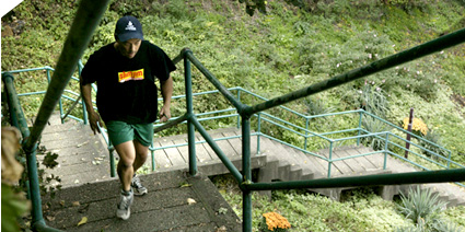
The Flats permit you to reserve your energy for your climb up the city steps (2) to the South Side Slopes. As residents settled on the Slopes, these concrete public steps were constructed to provide a mode of transport for workers “commuting” to and from the neighborhood’s steel mills. For a sampling of steps, take 18th Street towards the Slopes. At the bend in the road you’ll find a set of 122 stairs that takes you straight up the hillside to Pius Street. Whew! Once you’re at the top, pause to catch your breath—and take a moment to imagine the exhaustion that the South Side’s workers must have felt after a long day in a hot mill.
If you’ve had enough, you can return down the steps. But if you polished off a full stack of pancakes, you might consider extending your walk by turning right onto Pius Street, a narrow residential corridor lined with cliff-clinging houses. Towards the end of the street are two historic religious buildings of note. At 44 Pius Street is The Veronica’s Veil Auditorium, where community actors have been performing the Passion Play “Veronica’s Veil” since 1910.
At 1 Pius Street sits the former St. Michael’s Church and Rectory, a locally designated historic structure that’s now home to luxury condos. Take a look at the city view from here, and you’ll see what makes these living spaces so desirable. If you look across Pius Street uphill, you’ll see another quirky Pittsburgh tradition: a “paper street.” These public steps have a recognized street name (in this case, St. Michael’s Street) and appear as a street on a map, but it’s actually just a flight of steps. The formality of naming these public steps gives you a sense of the importance of the steps in the city’s history.
In about a half-mile walk, you can return to the Flats by continuing downhill on Brosville Street back towards the Flats. At the base of the hill, you can pick up 12th Street to Carson Street. A right turn on Carson will take you back to your starting point.
If you’re ready to refuel, the East Carson Street Business District (3) offers plenty of options for a healthful lunch. Or, on the lower end of Carson Street past the Birmingham Bridge, stop into R.E.I. (4) for an energy bar or take a shot at their indoor climbing wall. Or, charge ahead to a bike and boat adventure that will take you to the North Side neighborhood.
This afternoon, you’ll explore Pittsburgh’s three rivers by bike and boat. If you didn’t bring a bike to town, you can borrow one for free from the Dasani® Blue Bike Program managed by Friends of the Riverfront (5). During regular business hours, visit their South Side office for an access card, then get rolling on the Three Rivers Heritage Trail (6), a paved riverfront path that connects the city neighborhoods that lie along the banks of the Ohio, Allegheny, and Monongahela Rivers. The trail is suitable for biking, walking, and running. Although the trail does not yet provide a complete off-street path to the North Side, the Friends of the Riverfront staff can provide navigation tips for traveling through the Downtown central business district.
As you cruise past the lush green banks of the Monongahela (or, as locals know it, “The Mon”) and century-old buildings of the South Side, pause to read the Heritage Trail’s interpretative signage that describes the three rivers’ changing role in Pittsburgh’s growth. The rivers have been essential to Pittsburgh’s development: a strategic fort position during the French and Indian War; the “Gateway to the West” during the expeditions of Lewis & Clark; and a vital transportation system during the city’s manufacturing heyday. During the industrial boom, the rivers were highly polluted, but through the hard work of city leadership, they now provide a clean, lush natural retreat within the heart of the city.
Your destination on this venture: Kayak Pittsburgh (7) on the “North Shore” section of the North Side. Now that you’ve viewed the river from its banks, it’s time to get up close and personal. (You can deposit your bike at the North Side Blue Bike station near the Heinz Lofts and walk the short distance back to the rental station under the Roberto Clemente Bridge, or lock it up at the rental station.) No prior kayak experience is needed to enjoy this unique perspective of the city and its neighborhoods; the Kayak Pittsburgh staff will teach you all of the tips in a short on-shore lesson.
Once you launch onto the Allegheny River, you can create your own adventure. Head towards “the Point”, where our three rivers converge, or head upstream past the Strip District towards Herr’s Island, now known as Washington’s Landing. As you cruise along in tranquility, be sure to look beyond the river’s edge for glimpses of historic buildings that were once home to Pittsburgh’s industrial businesses—as well as some of its newest riverfront developments.
If you’re ready for refreshments, you have plenty of options just around the corner from the Kayak Pittsburgh rental station at the restaurants that line the streets surrounding PNC Park (8). Or, return your bike to the South Side for a bite or brew in the East Carson Street Business District.
This morning, we rise above the rivers and take to the park for a more freestyle active adventure. The City of Pittsburgh owns more than 1,700 acres of parkland, and today’s outing will begin at Schenley Park in the heart of Oakland. The park is named for Mary Croghan Schenley, the heiress who donated 400 acres of her inherited land to the City of Pittsburgh for the creation of a park in 1889. Take in a mid-morning breakfast and coffee at the Schenley Park Visitor Center Café (9), where you can learn more about the park, its history, and its current-day assets. Pop some quarters into the binoculars on the back patio for a view of Oakland and beyond.
Schenley Park’s abundant green space and recreational facilities make it a favorite spot for locals of any athletic persuasion. At the Visitor Center, you’ll find directions to lead you over the rolling hills and woodlands to the tennis courts, running tracks, hiking trails, public golf course, 18-hole disc golf course, and ice skating rink that are part of the park’s array of athletic offerings.
But you don’t need to be a tri-athlete to enjoy Schenley Park; leisurely strolls along the park’s paved hills are heartily encouraged. You can work your way into the park’s woodlands or climb to its hilltops for great views overlooking Oakland and beyond.
In the heart of Schenley Park you’ll find a well-preserved home. The Neill Log House (10) is one of the last three existing 18th century buildings in Pittsburgh. The home, which was probably built between 1769 and the mid-1770s, belonged at one time to Col. James O'Hara and his granddaughter Mary Schenley, the park’s founding donor. Restored by the Pittsburgh History and Landmarks Foundation and the Junior League, the house is now furnished with artifacts in keeping with a settler's life.
As you make your way back to the park’s Oakland entrance, take a side trip to Phipps Conservatory (11). A stroll around their plant collections and outdoor gardens is a relaxing place for a cool-down after your morning activity, and the Café Phipps serves up healthful dining and snacks with an emphasis on locally grown and organic foods.
Next up: Mount Washington. This hilltop neighborhood offers one of the finest views of the city, and this urban hike will allow you to revel in the scenery as you work your way across its ridgeline.
Mt. Washington sits atop a 400-foot slope once known as "Coal Hill", but you don’t need climbing gear to get there. Thankfully, our ancestors relieved us of the hike by introducing what Pittsburghers call “inclines” to the neighborhood. Two of these historic funicular railcars remain in operation today, and we’ll use both in our trek.
To get started, travel west on Carson Street past Station Square (12), a shopping and entertainment complex housed in an refurbished rail station near the Smithfield Street Bridge. Just past the main buildings, you’ll see a sign on an over-the-road walkway for the Duquesne Incline (13), built in 1877. If you’re arriving by car, parking in this lot is free; If you brought a bike, you can bring it with you on the ride. For just a couple of bucks, they’ll help you scale the hill in minutes, and you can brush up on local history at the exhibits in the station.
Once you exit the station, take a left and start your venture east on Grandview Avenue. You’ll pass by the neighborhood’s Restaurant Row, a collection of fine dining spots. Continue straight through the intersection of Grandview, P.J. McArdle Roadway, and Merrimac Streets.
From this point on, Grandview Avenue’s cliffside is undeveloped, giving you wide open views of the Downtown central business district skyline and the three rivers—as well as some neighborhood’s you’ve already visited. Look towardthe east, and you’ll see the Cathedral of Learning rising in Gothic grandeur from the plateau of Oakland. Look below, and the South Side Flats sprawl out at your feet. And across the Allegheny River, you’ll recognize spots from your kayak adventure on the North Side.
If you are ready to pause, stop into the Mt. Washington branch of the Carnegie Library (14). This branch opened in 1900, and the building is now a locally designated historic landmark.
Continue down Grandview Avenue toward the Monongahela Incline (15), which will carry you back down to your starting point at Station Square. Be sure to take a front seat so you can savor the view for the final time.
Note for competitive cyclists or runners: Sycamore Street, which connects Carson Street to Mt. Washington is incredibly steep and twisted. It’s manageable—the city once hosted a cycling race here—but definitely a challenge.
This morning, we head to Lawrenceville for a trip through Allegheny Cemetery (16), one of the area’s oldest and largest burial grounds. For a homestyle breakfast, stop into Barb’s Corner Kitchen (17), located just across the street from the cemetery entrance on Butler Street.
Although biking and pets are not permitted on the cemetery’s paved paths, walkers and runners are welcome to explore the hills and valleys of the historic 300-acre grounds. If you arrive during business hours, stop into the administrative offices at the Butler Street gatehouse, and they’ll provide a map highlighting historic and monumental burial spots.
Along your explorations, you’ll cover grounds including wooded areas, ponds, fountains, and open fields filled with monuments dating back to the cemetery’s opening in 1845. The cemetery was modeled after the landscape design that was fashionable in England at that time.
As you make your way through, keep an eye out for the “notables” laid to rest here. American songwriter Stephen Foster (Section 21; Lot 30) is among the most famous; his father was the original developer of the Lawrenceville community. Baseball Hall of Famer Josh Gibson (Section 50; Lot SG-C232), a former Pittsburgh resident and star of two Pittsburgh area Negro League teams: the Pittsburgh Crawfords and the Homestead Grays. In addition, you’ll find many of the names that now grace the city’s streets and buildings, including Mellon, Negley, Neville, and Wilkins.
After your hike, continue walking through the business district on Butler Street, where specialty shops and art galleries mingle with neighborhood schools and banks in historic architecture. And if you have a kayak or canoe in tow, you can cast off in Lawrenceville: there’s a launch at the end of 43rd Street just past the concrete plant.
If you’re still in the mood for a stroll, follow the Strip District’s walking tour, which points out sites of historic interest in the heart of the neighborhood or try one of the themed Strictly Strip Tours.

Taken this Tour?
Been to a destination listed here?
Share your story! >>


This Project was financed by a grant from the Commonwealth of Pennsylvania
Department of Community and Economic Development.


 view map (pdf)
 print